Where is June Lake?
People ask where is June Lake? Well it’s in the Eastern Sierra Mountains. On the East Side between Mammoth Lakes and Yosemite National Park.
For direction’s, we are just off Highway 395 on the June Lake loop, Highway 158. We have no physical address, but from the north or south entrees to Highway 158, we are in the middle, adjacent to Silver Lake. We have a big sign and you will see the horses.
- From Bay Area: Drive via US-395 N/Hwy 395 N/U.S. Hwy 395 N and US-50 W/El Dorado Fwy / U.S. Route 50 in California · 322 mi
6 h 13 min - From Los Angeles: Drive via US-395 N/Hwy 395 N/U.S. Hwy 395 N · 341 mi
5h 53m - From Orange County,CA: Drive via US-395 S/Hwy 395 S/U.S. Hwy 395 S · 361 mi
6h 19m - From Reno Airport: Drive via US-395 S/Hwy 395 S/U.S. Hwy 395 S · 150 mi Turn on June Lake loop
2 h 41 min
From the Silver Lake Trailhead you can reach the following:
Agnew Lake: It is 37 acres at an elevation of 8,508 feet and is a 2 hour hike out of Silver Lake Pack Station of 2 miles with a 1300 foot gain. Agnew was a natural lake that was expanded by a dam in the 1920’s. It provides the hydroelectric power for the communities of Mammoth Lakes, June Lake, and Lee Vining. Acess is very limited due to the steepness of the shoreline. Contains Rainbows and Brookies.
Gem Lake: 246 acre lake at 9050 feet and is about 2.6 miles from the trailhead. It is named “Gem” due to Theodore Agnew’s reference of this lake being the “Gem-O’-the-Mountains” and referenced as such in McClure’s mapping of the area in 1896. Gem was a natural lake that was dammed in the early 1920’s to create a much larger lake. Gem Lake contains Rainbows and Brookies. The best areas are the Rush Creek and Crest Creek inlets, particularly in the Spring.
Alger Lakes: Going around the northern shore of Gem Lake, the trail forks to Alger Lakes about 4 miles from the trailhead. Follow the trail northwards for about 3.6 miles with a 1500 foot gain. Alger consists of three lakes at an elevation of 10,700 feet . Two lakes are 45 acres and one lake is 18 acres. The lakes were named for John Alger, a packer for the USGS in 1909. The lakes contain Golden Trout and is about a 6-7 hour hike from the Silver Lake Pack Station. Obviously, a visit to Algers would best be an overnight one. Most use the lower lake for camping. The lakes are prone to windy conditions with strong up-slope winds during the day bringing terrestrials such as ants and beetles to the lakes.
Rush Creek: Within the backcountry, Rush Creek is unfishable between Agnew Lake and June Lake Loop Road due to grade. It is fishable between Gem and Waugh Lake. This area covers about 1.7 miles from 9,100 feet to 9,420 feet as a freestone stream. From the backside of Gem Lake you are about 4.5 miles from the trailhead. Contains Rainbows and Brookies. The forks area of Rush Creek above Waugh Lake near the John Muir Trail/PCT is another good section to fish containing brookies in the 8 inch class.
Waugh Lake: About 6 miles from the Trailhead at an elevation 9,420 feet. The trail follows the northern shoreline for about 1.7 miles. Waugh Lake is actually a reservoir when Upper Rush Creek Meadow was dammed in 1919. The lake is not planted but does contain Brookies from Upper Rush Creek and other tributaries. Often the lake is drawn quite low by Fall and the trout tend to migrate back into the streams.
Lost Lakes: At the northwest shore of Waugh Lake you must follow the outlet creek of Lost Lakes northward off-trail for 1.5 miles to reach the first lake. The elevation is 10,600 . Following the inlet creek on the northern shore you can reach the second lake in about .75 miles at an elevation of 11,050 . The third lake is the largest and is about .5 miles northwest of the second lake at an elevation of 10,960 feet. Each lake consists of Goldens.
Weber Lake: Taking the south fork of the trail at the eastern side of Waugh Lake, you can reach this lake in another .8 miles or 6.8 miles total from the Trailhead. Elevation is 9900 feet with a 500 foot gain above Waugh. Consists of Brookies.
Sullivan Lake: The trail drops down 200 feet and ends at Sullivan Lake at an elevation is 9400 feet. It is 1.25 miles from the trail fork at Waugh Lake or a total of 7.25 miles from the trailhead. Consists of Brookies.
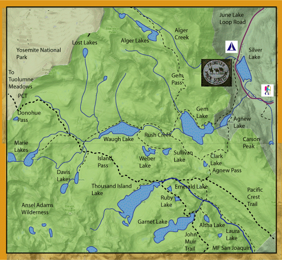 Clark Lakes: Clark Lakes consists of about 5 small lakes. Best reached by taking the southern trail from the eastern shore of Agnew Lake. There is a gain of 1500 feet over 1.7 miles from Agnew or a total of 3.7 miles from the trailhead. The elevation of the first lake is 9950 feet. The largest lake is .5 miles further at an elevation of 9800 feet. All of the lakes have good Brookie fishing. Clark Lake #3,4, and 5 were planted with Goldens in 1999 but reports are that these plants were eaten by the larger Brookies. Clark Lake #1 is the closest to Agnew Lake and the lakes are numbered from east to west. Clark #2 is the largest with the most fish. The shorelines are easily waded with both dries and nymphs being productive.
Thousand Island Lake: The lake is one of the largest high-country lakes at 320 acres at an elevation of 9,850 feet and is the headwaters for the San Joaquin River. John Muir considered it to be the most beautiful lake within the Sierras. It is about 6.3 miles from the trailhead at an elevation of 9850 feet. The lake has over 6 miles of shoreline. Flyfishing is particularly good during the late Spring and early Summer after Ice-out. After that period, the trout tend to stay within deeper water out of reach of a flyline. The DFG plants about 30,000 fingerlings annually. These generally holdover into a size range of 9-10 inches. The lake is reknowned for it’s windy conditions and camping restrictions apply. Consists of Rainbows and Brookies.
Emerald Lake: This 7 acre lake is about .5 miles southeast of Thousand Island Lake or 6.74 miles from the trailhead. Elevation is 9880 feet. Emerald is a good place to camp if nearby Thousand Island Lake is full. It has a fair fishing during the low light periods of the day. Consists of Rainbows and Brookies.
Ruby Lake: This 10 acre lake is 7.1 miles from the trailhead, about .25 miles past Emerald Lake. Elevation is 9880 feet. The shoreline along the trail is fishable. Consists of Rainbows.
Garnet Lake: The trail drops down from Ruby to 212 acre Garnet Lake over .75 miles or 7.9 miles from the trailhead. The trail follows the northern shore to the outlet creek which drops to the MF San Joaquin River. Elevation is 9840 feet. About 18,000 fingerling rainbows are planted annually resulting in some good fishing with ‘bows in the 10-14 inch range. The lake consists of about 100 small islands. Consists of Rainbows and Brookies.
Altha Lake: This 14 acre lake is about 8.5 miles from the trailhead. Elevation is 9680 feet. Usually has a good evening bite. Consists of Rainbows.
Laura Lake: This lake can be reached from Altha Lake by going off-trail about .75 miles southeast or 9.2 miles from the trailhead. Elevation is 9600 feet. Popular with Packers due to the good horse camping sites. Consists of Rainbows mostly in the 8-9 inch class.
Davis Lakes: From the western shore of Waugh Lake, you can take the trail further to Davis Lakes. Consists of two lakes about 9.4 miles from the trailhead. Elevation is 9,900 feet for the first lake and 10,275 feet for the second lake. These lakes are prone to windy conditions. The shorelines are rocky with drop-offs holding trout. The outlet of the lower lake tends to be shallow and a good dry fly opportunity. Consists of Brookies.
Marie Lakes: Going westward from Waugh Lake, you meet the PCT, Follow the PCT northward and the trail forks off to the west in about .75 miles. The lakes are 10.25 miles from the trailhead. Two lakes, one at 10,850 feet and the other at 11,240 feet. Consists of Rainbows.